


Archived Miami Comprehensive Neighborhood Plan (MCNP)
The MCNP is Revised through First Round of EAR-Based Amendments As of May 14, 2018
By State Statute, each City and County in Florida must adopt a
comprehensive plan and also adopt land development regulations to
implement the comprehensive plan.
The Miami Comprehensive Neighborhood Plan (MCNP) was adopted as
Ordinance 10544 on February 9, 1989 and contains amendments by the
City Commission through December 2017. The purpose of the MCNP is to
indicate how the City will meet the needs of existing and future
residents, visitors, and businesses, while preserving the character
and quality of its communities. MCNP creates a policy framework that
has the effect of law, to guide all public and private development
decisions in the City. MCNP consists of materials (written and
graphic) that describe the principles, guidelines, and standards for
the orderly and balanced future development of the City (economic,
social, physical, environmental, and fiscal development). The
Chapters or "elements" of the MCNP encompass Goals, Objectives, and
Policies for future land use, housing, parks, transportation,
capital improvements, intergovernmental coordination, etc.
Implementation of the MCNP occurs through City land
development regulations such as the zoning code, detailed housing
plans, historic preservation code, environmental preservation code,
and specific district or sector plans.
You can
access the latest version of the MCNP
here, adopted by City Commission on December 14, 2017.
Appendices as of February 2017
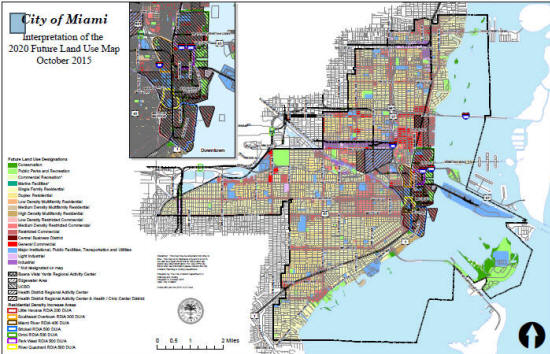
- LU-1 (Land Use Map Series) Updated October 2015
- TR-1 (Transportation -Data Inventory and Analysis)
- PA-1 (Working Waterfront)
- CM-1 (Coastal Area Management Maps) Updated October 2015
- EDU-1 (Public School and Ancillary Facilities Maps)
- CI-1 (Capital Improvements Program)
- PW-1 (Water Supply Facilities Work Plan Update-September 2015)
2020 Future Land Use Map
The 2020 Future Land Use Map is a planning instrument designed to guide the future development and distribution of the land uses within the City in a manner that is consistent with the goals, objectives, and policies of the Miami Comprehensive Neighborhood Plan (MCNP). 2020 Future Land Use Maps.